
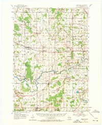
1954 Map of Reedsville
USGS Topo · Published 1956About this map
The Manitowoc River and Branch River snake through a landscape of dairy farms and rural crossroads in the mid-1950s. This agricultural region is defined by a dense network of one-room schoolhouses such as Lowell Sch, Niles Sch, and Cedar Grove Sch, reflecting the community-centric layout of the era before widespread school consolidation. Larger settlements like Reedsville and Valders serve as commercial anchors along the Chicago And North Western and Minneapolis ST Paul And Sault Ste Marie rail lines, which were vital for transporting local goods. The presence of the Maple Crest Sanatorium near Whitelaw and the religious community around St Nazianz, including Lake Oschwald, highlights the distinct social and institutional character of central Manitowoc County. Numerous Gravel Pit and Quarry sites across the terrain indicate the importance of local stone for the region's infrastructure and development.
Find a feature on this map
87 named features on this map. Tap any name to fly to it.
Don’t see what you’re looking for? This feature index may not catch every label — zoom into the map to look around manually.
Map Details
Editions of this 1954 Reedsville Map
2 editions found
Other maps of this area

1954 · De Pere
USGS Topo · 1:62,500

1954 · Kewaunee
USGS Topo · 1:62,500

1954 · School Hill
USGS Topo · 1:24,000

1954 · Manitowoc
USGS Topo · 1:62,500

1954 · Cleveland
USGS Topo · 1:24,000

1954 · St. Wendel
USGS Topo · 1:24,000

1954 · Sheboygan North
USGS Topo · 1:62,500

1954 · Denmark
USGS Topo · 1:62,500

1954 · Howards Grove
USGS Topo · 1:62,500

1954 · Chilton
USGS Topo · 1:62,500