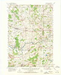
1954 Map of Reedsville
USGS Topo · Published 1972About this map
The Manitowoc River and its tributary, the Branch River, wind through a landscape of dairy farms and rural crossroads in the mid-1950s. This survey of Manitowoc County reveals a high density of rural education, identifying numerous local schoolhouses such as Lowell Sch and Marquette Sch, alongside several noted as defunct, including Elm View Sch and Brookside Sch. These markers, coupled with community hubs like the Poplar Grove Community Center, provide a detailed record of the mid-century social fabric.
Find a feature on this map
85 named features on this map. Tap any name to fly to it.
Don’t see what you’re looking for? This feature index may not catch every label — zoom into the map to look around manually.
Map Details
Editions of this 1954 Reedsville Map
2 editions found

Other maps of this area

1954 · De Pere
USGS Topo · 1:62,500

1954 · Kewaunee
USGS Topo · 1:62,500

1954 · School Hill
USGS Topo · 1:24,000

1954 · Manitowoc
USGS Topo · 1:62,500

1954 · Cleveland
USGS Topo · 1:24,000

1954 · St. Wendel
USGS Topo · 1:24,000

1954 · Sheboygan North
USGS Topo · 1:62,500

1954 · Denmark
USGS Topo · 1:62,500

1954 · Howards Grove
USGS Topo · 1:62,500

1954 · Chilton
USGS Topo · 1:62,500