
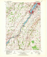
1954 Map of De Pere
USGS Topo · Published 1956About this map
The Fox River serves as the industrial and navigational spine of this mid-1950s survey, connecting the urban centers of De Pere, Ashwaubenon, and Allouez with the outlying farming townships. The waterway is heavily managed by engineering works such as the Little Kaukauna Lock and Dam and the Rapide Croche Lock and Dam, facilitating movement between the industrial valley and Lake Michigan. Beyond the river banks, the landscape is dotted with a dense network of country schools and rural cemeteries, reflecting a deeply rooted settlement pattern. Notable institutions like the Hickory Grove Sanatorium and the State Reformatory occupy significant tracts, while aviation infrastructure is represented by the burgeoning Austin Straubel Airport and the smaller Nicolet Airport. This era captures the transition of the region from purely agricultural townships like Lawrence and Rockland toward more organized suburban and municipal growth.
Find a feature on this map
86 named features on this map. Tap any name to fly to it.
Don’t see what you’re looking for? This feature index may not catch every label — zoom into the map to look around manually.
Map Details
Editions of this 1954 De Pere Map
2 editions found
Other maps of this area

1911 · Neenah
USGS Topo · 1:62,500

1954 · Green Bay West
USGS Topo · 1:24,000

1954 · Denmark
USGS Topo · 1:62,500

1954 · De Pere
USGS Topo · 1:24,000

1954 · New Franken
USGS Topo · 1:62,500

1954 · Green Bay East
USGS Topo · 1:24,000

1954 · Chilton
USGS Topo · 1:62,500

1954 · Reedsville
USGS Topo · 1:62,500

1954 · Manitowoc
USGS Topo · 1:250,000

1954 · Bellevue
USGS Topo · 1:24,000