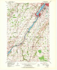
1954 Map of De Pere
USGS Topo · Published 1971About this map
The Fox River corridor in the mid-1950s serves as the industrial and transportation spine of this region, connecting Green Bay and De Pere to the river towns downstream. The landscape is a mix of expanding suburban footprints in Allouez and Ashwaubenon and the traditional farming communities of Wrightstown and Holland. This era is defined by heavy infrastructure and institutional presence, ranging from the Austin Straubel Airport to the State Reformatory. Along the river, specialized water management is evident at the Rapide Croche Lock and Dam and the Little Kaukauna Lock and Dam. Local history is preserved in the numerous rural schools like Old Glory Sch and Silvery Summit Sch, many of which were already marked as abandoned by the time of this survey, reflecting the consolidation of the rural education system in Brown Co.
Find a feature on this map
90 named features on this map. Tap any name to fly to it.
Don’t see what you’re looking for? This feature index may not catch every label — zoom into the map to look around manually.
Map Details
Editions of this 1954 De Pere Map
2 editions found
Other maps of this area

1911 · Neenah
USGS Topo · 1:62,500

1954 · De Pere
USGS Topo · 1:62,500

1954 · Green Bay West
USGS Topo · 1:24,000

1954 · Denmark
USGS Topo · 1:62,500

1954 · De Pere
USGS Topo · 1:24,000

1954 · New Franken
USGS Topo · 1:62,500

1954 · Green Bay East
USGS Topo · 1:24,000

1954 · Chilton
USGS Topo · 1:62,500

1954 · Reedsville
USGS Topo · 1:62,500

1954 · Manitowoc
USGS Topo · 1:250,000