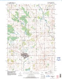
1992 Map of Reedsville
USGS Topo · Published 1996About this map
Reedsville sits at the heart of this agricultural and wetland landscape on the border of Brown Co and Manitowoc Co as it appeared in the early 1990s. The village serves as a central hub, surrounded by a network of rural settlements including Menchalville, Maple Grove, and Grimms. The terrain is shaped by the winding course of the Branch River and the meandering Mud Creek, interspersed with numerous Gravel Pits and a Quarry that indicate the local extraction industry.
Find a feature on this map
49 named features on this map. Tap any name to fly to it.
Don’t see what you’re looking for? This feature index may not catch every label — zoom into the map to look around manually.
Map Details
Editions of this 1992 Reedsville Map
This is the sole edition of this map. No revisions or reprints were ever made.
Other maps of this area

1954 · De Pere
USGS Topo · 1:62,500

1954 · Denmark
USGS Topo · 1:62,500

1954 · Chilton
USGS Topo · 1:62,500

1954 · Reedsville
USGS Topo · 1:62,500

1954 · Manitowoc
USGS Topo · 1:250,000

1955 · Green Bay
USGS Topo · 1:250,000

1958 · Manitowoc
USGS Topo · 1:250,000

1974 · Brillion
USGS Topo · 1:24,000
1974 · Potter
USGS Topo · 1:24,000

1974 · Greenleaf
USGS Topo · 1:24,000