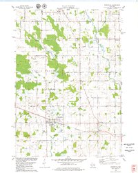
1978 Map of Reedsville
USGS Topo · Published 1979About this map
The Chicago and North Western railroad corridor anchors this late-1970s landscape of eastern Wisconsin, cutting through the village of Reedsville. This area of Manitowoc County is defined by a dense network of dairy farms and rural crossroads, where the terrain transitions from the headwaters of Mud Creek to the banks of the Branch River. The map reveals a deeply rooted community structure, evidenced by numerous historical burial grounds like Frieden Cem and St Marys Cem, and smaller settlements such as Menchalville and Grimms. The local economy of the era is marked by industrial sites including a Quarry and Kilns near the southern boundary, reflecting the region's long-standing relationship with its geological resources. Field and fence lines, identified from 1976 aerial photography, illustrate the precise boundaries of agricultural life in townships like Maple Grove and Morrison.
Find a feature on this map
47 named features on this map. Tap any name to fly to it.
Don’t see what you’re looking for? This feature index may not catch every label — zoom into the map to look around manually.
Map Details
Editions of this 1978 Reedsville Map
This is the sole edition of this map. No revisions or reprints were ever made.
Other maps of this area

1954 · De Pere
USGS Topo · 1:62,500

1954 · Denmark
USGS Topo · 1:62,500

1954 · Chilton
USGS Topo · 1:62,500

1954 · Reedsville
USGS Topo · 1:62,500

1954 · Manitowoc
USGS Topo · 1:250,000

1955 · Green Bay
USGS Topo · 1:250,000

1958 · Manitowoc
USGS Topo · 1:250,000

1974 · Brillion
USGS Topo · 1:24,000
1974 · Potter
USGS Topo · 1:24,000

1974 · Greenleaf
USGS Topo · 1:24,000