
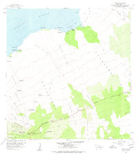
1959 Map of Kiholo
USGS Topo · Published 1960About this map
The vast volcanic landscape of the North Kona District is defined here by the massive Kaupulehu Lava Flow and the prominent Puu Waawaa cinder cone. This 1959 survey documents the intricate intersection of ancient geological events and human transit, showing the Lava Flow of 1801 and the Lava Flow of 1859 cutting across the terrain toward the Pacific Ocean. Settlement is concentrated at Huehue Ranch and the coastal area of Kiholo, where the Kiholo-Puako Trail skirts the shoreline. Inland, the Mamalahoa Highway serves as the primary artery, passing through the Kaulana Homesteads. Numerous cinder cones or 'puu', such as Puu Nahaha and Puu Aiauawa, dot the coastal plains and uplands, providing essential landmarks for navigation across the seemingly uniform fields of lava and scrub.
Find a feature on this map
53 named features on this map. Tap any name to fly to it.
Don’t see what you’re looking for? This feature index may not catch every label — zoom into the map to look around manually.
Map Details
Editions of this 1959 Kiholo Map
2 editions found
Other maps of this area

1928 · Puako
USGS Topo · 1:62,500

1928 · Kailua
USGS Topo · 1:62,500

1954 · Hawaii North
USGS Topo · 1:250,000

1956 · Puu Hinai
USGS Topo · 1:24,000

1959 · Hawaii North
USGS Topo · 1:250,000

1959 · Hualalai
USGS Topo · 1:24,000
1959 · Anaehoomalu
USGS Topo · 1:24,000

1959 · Makalawena
USGS Topo · 1:24,000

1959 · Keahole Point
USGS Topo · 1:24,000
1959 · Puu Anahulu
USGS Topo · 1:24,000