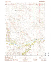
1985 Map of Kilgore SE
USGS Topo · Published 1985About this map
The Niobrara River carves a winding path through the northern Nebraska sandhills on this 1980s provisional survey. The landscape is defined by the confluence of the Snake River and the Niobrara, where deep incisions like Cox Canyon break the upland plateau. Human presence is sparse and predominantly agricultural, marked by established cattle operations such as Schloter Ranch, Bush Ranch, and Peterson Ranch. On the level ground of Church Flat, the grid of section lines and range roads provides the primary structure for movement across the terrain. A single rural schoolhouse, School No 45, and a lone Radio Tower serve as the principal landmarks in this expansive ranching district of Cherry County. The map captures a moment when traditional land use patterns remained dominant, with very little modern infrastructure beyond the essential ranch buildings and perimeter fencing.
Find a feature on this map
9 named features on this map. Tap any name to fly to it.
Don’t see what you’re looking for? This feature index may not catch every label — zoom into the map to look around manually.
Map Details
Editions of this 1985 Kilgore SE Map
This is the sole edition of this map. No revisions or reprints were ever made.
Other maps of this area

1950 · Simeon
USGS Topo · 1:62,500

1950 · Kennedy
USGS Topo · 1:62,500

1950 · Kilgore
USGS Topo · 1:62,500

1950 · Valentine
USGS Topo · 1:62,500

1957 · Valentine
USGS Topo · 1:250,000

1959 · Valentine
USGS Topo · 1:250,000
1983 · Crookston East
USGS Topo · 1:24,000

1983 · Valentine SW
USGS Topo · 1:24,000

1985 · Cooper Canyon
USGS Topo · 1:24,000
1985 · Crookston West
USGS Topo · 1:24,000