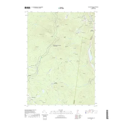
2018 Map of Killington Peak
USGS Topo · Published 2018About this map
Killington Peak and the surrounding Green Mountains define this high-elevation landscape in Rutland and Windsor counties. The modern path of the Appalachian National Scenic Trail winds through the terrain, passing between Snowden Peak and Mendon Peak before descending toward the Cold River valley. This 2018 survey captures the interface of high-altitude recreational landmarks and the small, persistent mountain settlements like North Shrewsbury and West Bridgewater. Genealogists will find several burial grounds noted, including the Northam Cem and the Church of Our Saviour Cem, which sit alongside the Ottauquechee River. The network of local routes, such as Old Plymouth Rd and Tin Shanty Rd, provides a detailed view of the rural access points used to navigate these steep ridgelines and the Coolidge Range.
Find a feature on this map
93 named features on this map. Tap any name to fly to it.
Don’t see what you’re looking for? This feature index may not catch every label — zoom into the map to look around manually.
Map Details
Editions of this 2018 Killington Peak Map
This is the sole edition of this map. No revisions or reprints were ever made.
Other maps of this area

1891 · Rutland
USGS Topo · 1:62,500

1893 · Wallingford
USGS Topo · 1:62,500

1893 · Rutland
USGS Topo · 1:62,500

1911 · Woodstock
USGS Topo · 1:62,500

1913 · Woodstock
USGS Topo · 1:62,500

1928 · Ludlow
USGS Topo · 1:48,000

1929 · Ludlow
USGS Topo · 1:62,500

1932 · Ludlow
USGS Topo · 1:62,500

1943 · Woodstock
USGS Topo · 1:62,500

1950 · Glens Falls
USGS Topo · 1:250,000