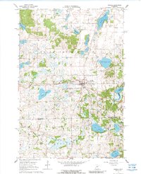
1967 Map of Kimball
USGS Topo · Published 1988About this map
Kimball (Kimball Prairie) serves as the primary hub of this landscape at the intersection of local township lines and the Soo Line railroad. The village is well-documented with civic and leisure landmarks, including the Kimball Airport, a Drive-in Theater, and the Kimball Cem. To the south, the village of St Annes Cem is noted near the winding path of the Clearwater River.
Find a feature on this map
28 named features on this map. Tap any name to fly to it.
Don’t see what you’re looking for? This feature index may not catch every label — zoom into the map to look around manually.
Map Details
Editions of this 1967 Kimball Map
2 editions found
Other maps of this area

1951 · Annandale
USGS Topo · 1:62,500

1953 · Saint Cloud
USGS Topo · 1:250,000

1957 · Saint Cloud
USGS Topo · 1:250,000

1958 · Saint Cloud
USGS Topo · 1:250,000

1958 · Dassel
USGS Topo · 1:62,500

1958 · Cokato
USGS Topo · 1:62,500

1967 · Cold Spring
USGS Topo · 1:24,000

1967 · Watkins
USGS Topo · 1:24,000

1967 · Rockville
USGS Topo · 1:24,000

1967 · Kimball
USGS Topo · 1:24,000
Featured Places
- Kimball, MN
- Fair Haven Township, MN
- Maine Prairie Township, MN
- Southside Township, MN
- Stearns County, MN