
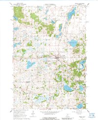
1967 Map of Kimball
USGS Topo · Published 1969About this map
Kimball (Kimball Prairie) serves as the central hub of this Central Minnesota landscape, situated at a junction of the Soo Line railroad. The town's mid-century character is defined by a mix of traditional and modern landmarks, from the Kimball Cem and St Annes Cem to the Drive-in Theater and Kimball Airport. The surrounding topography is a dense network of glacial water bodies, including School Section Lake, Carnelian Lake, and Lake Betsy, many of which are connected by the Clearwater River. Local industry and recreation are evident through numerous gravel pits and the presence of Ski Lifts on the prairie slopes. The map also captures the convergence of Stearns, Meeker, and Wright counties, reflecting the intricate political and natural boundaries of the Maine Prairie and Fairhaven regions during the late 1960s.
Find a feature on this map
31 named features on this map. Tap any name to fly to it.
Don’t see what you’re looking for? This feature index may not catch every label — zoom into the map to look around manually.
Map Details
Editions of this 1967 Kimball Map
2 editions found
Other maps of this area

1951 · Annandale
USGS Topo · 1:62,500

1953 · Saint Cloud
USGS Topo · 1:250,000

1957 · Saint Cloud
USGS Topo · 1:250,000

1958 · Saint Cloud
USGS Topo · 1:250,000

1958 · Dassel
USGS Topo · 1:62,500

1958 · Cokato
USGS Topo · 1:62,500

1967 · Cold Spring
USGS Topo · 1:24,000

1967 · Watkins
USGS Topo · 1:24,000

1967 · Rockville
USGS Topo · 1:24,000
1974 · St Augusta
USGS Topo · 1:24,000
Featured Places
- Kimball, MN
- Fair Haven Township, MN
- Maine Prairie Township, MN
- Southside Township, MN
- Stearns County, MN