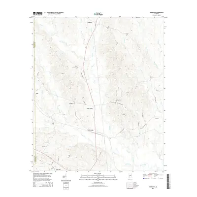
2014 Map of Kimbrough
USGS Topo · Published 2014About this map
The junction at Kimbrough serves as a focal point for this rural Wilcox County landscape, where the north-south corridor of Al-5 and Al-162 meets a complex network of local routes like Korea Rd. The terrain is deeply etched by a dense drainage system, including the meandering paths of Goose Creek and Turkey Creek, which define the agricultural and timbered patches of the region. This 2014 survey reveals a dispersed settlement pattern characteristic of Alabama's Black Belt, anchored by historic communities such as Lamison, Arlington, and Anne Manie. Genealogy and local history researchers will find a significant concentration of burial sites throughout the quadrangle, including Saint Matthews Cem, Goshen Cem, and Dunaway Cem. These landmarks, along with family-named roads like Sam Nettles Rd and Jessie Anderson Rd, provide essential reference points for tracing property lines and family origins in this part of the state.
Find a feature on this map
67 named features on this map. Tap any name to fly to it.
Don’t see what you’re looking for? This feature index may not catch every label — zoom into the map to look around manually.
Map Details
Editions of this 2014 Kimbrough Map
This is the sole edition of this map. No revisions or reprints were ever made.
Other maps of this area

1953 · Montgomery
USGS Topo · 1:250,000

1953 · Andalusia
USGS Topo · 1:250,000

1956 · Montgomery
USGS Topo · 1:250,000

1957 · Montgomery
USGS Topo · 1:250,000

1957 · Andalusia
USGS Topo · 1:250,000

1973 · Coy
USGS Topo · 1:24,000

1973 · Pine Hill
USGS Topo · 1:24,000

1973 · Thomasville
USGS Topo · 1:24,000

1974 · Catherine
USGS Topo · 1:24,000
1974 · Lee Long Bridge
USGS Topo · 1:24,000