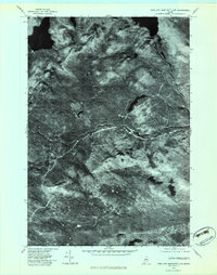
1977 Map of King And Bartlett Lake
USGS Topo · Published 1983About this map
King And Bartlett Lake and the surrounding wilderness of Somerset County are depicted through high-altitude aerial imagery captured in late 1977. This orthophotoquad provides a clear view of the deep woods and hydrologic patterns before modern development, focusing on the drainage systems of Little Spencer Stream and Spencer Stream. The terrain is defined by the prominent elevations of Bear Mountain and Burnt Hill, which overlook a network of smaller water bodies including Shaw Pond and the headwaters of Halfway Brook. The map serves as a precise record of forest cover and shoreline configurations, specifically highlighting the northern reaches of Spencer Lake. It is a valuable resource for understanding the remote landscape as it existed during the late seventies, free from the interpretive smoothing of traditional topographic contouring.
Find a feature on this map
8 named features on this map. Tap any name to fly to it.
Don’t see what you’re looking for? This feature index may not catch every label — zoom into the map to look around manually.
Map Details
Editions of this 1977 King And Bartlett Lake Map
This is the sole edition of this map. No revisions or reprints were ever made.
Other maps of this area

1925 · Pierce Pond
USGS Topo · 1:48,000

1927 · Pierce Pond
USGS Topo · 1:62,500

1928 · Spencer
USGS Topo · 1:48,000

1928 · Dead River
USGS Topo · 1:62,500

1928 · Stratton
USGS Topo · 1:48,000

1931 · Dead River
USGS Topo · 1:48,000

1932 · Stratton
USGS Topo · 1:62,500

1932 · Spencer
USGS Topo · 1:62,500

1944 · Dead River
USGS Topo · 1:62,500

1944 · Pierce Pond
USGS Topo · 1:62,500
Featured Places
- Flagstaff Township, ME
- T3 R5 BKP WKR, ME
- Spring Lake Township, ME
- King & Bartlett Township, ME
- Somerset County, ME