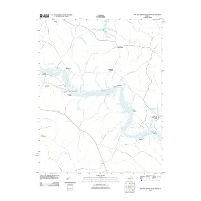
2011 Map of King And Queen Court House
USGS Topo · Published 2011About this map
King and Queen Court House serves as the focal point of this Virginia tidewater landscape, where the historic county seat sits near the banks of the winding Mattaponi River. The river's deep meanders dictate the local geography, lined with numerous historical river access points such as Courthouse Landing, Log Landing, and White Oak Landing. These landings, along with the Mantua Ferry site, point to a long-standing reliance on the river for transport and commerce before modern road networks dominated the interior.
Find a feature on this map
68 named features on this map. Tap any name to fly to it.
Don’t see what you’re looking for? This feature index may not catch every label — zoom into the map to look around manually.
Map Details
Editions of this 2011 King And Queen Court House Map
This is the sole edition of this map. No revisions or reprints were ever made.
Other maps of this area

1918 · Tappahannock
USGS Topo · 1:62,500

1918 · Aylett
USGS Topo · 1:62,500

1919 · New Kent
USGS Topo · 1:62,500

1919 · Tappahannock
USGS Topo · 1:62,500

1920 · King William
USGS Topo · 1:62,500

1933 · Aylett
USGS Topo · 1:62,500

1943 · Richmond
USGS Topo · 1:250,000

1944 · Dunnsville
USGS Topo · 1:31,680
1944 · Howertons
USGS Topo · 1:24,000
1945 · Howertons
USGS Topo · 1:31,680