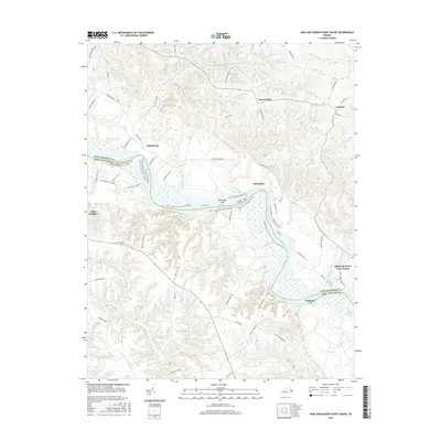
2016 Map of King And Queen Court House
USGS Topo · Published 2016About this map
The Mattaponi River serves as the primary geographical divider between King and Queen and King William counties, carving a winding path through a landscape defined by extensive wetlands and tidal marshes. Along its banks, the river features notable navigational points such as De Farges Bar and is fed by a complex network of tributaries including Cohoke Mill Creek, Brooks Creek, and Garnetts Creek. The surrounding terrain is heavily influenced by hydrology, evidenced by the large interior wetlands of Exol Swamp and Indian Town Swamp.
Find a feature on this map
70 named features on this map. Tap any name to fly to it.
Don’t see what you’re looking for? This feature index may not catch every label — zoom into the map to look around manually.
Map Details
Editions of this 2016 King And Queen Court House Map
This is the sole edition of this map. No revisions or reprints were ever made.
Other maps of this area

1918 · Tappahannock
USGS Topo · 1:62,500

1918 · Aylett
USGS Topo · 1:62,500

1919 · New Kent
USGS Topo · 1:62,500

1919 · Tappahannock
USGS Topo · 1:62,500

1920 · King William
USGS Topo · 1:62,500

1933 · Aylett
USGS Topo · 1:62,500

1943 · Richmond
USGS Topo · 1:250,000

1944 · Dunnsville
USGS Topo · 1:31,680
1944 · Howertons
USGS Topo · 1:24,000
1945 · Howertons
USGS Topo · 1:31,680