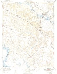
1949 Map of King William
USGS Topo · Published 1949About this map
Pamunkey River and Mattaponi River shoreline life defines this coastal plain landscape in the late 1940s. The region is marked by historic river access points such as Roanes Wharf, Grimes Landing, and the Piping Tree Ferry, reflecting an era when these waterways were vital conduits for commerce and local travel. Inland, the topography is carved by tidal tributaries like Acquinton Creek and Jacks Creek, which separate small agricultural communities and family estates like Chericoke.
Find a feature on this map
38 named features on this map. Tap any name to fly to it.
Don’t see what you’re looking for? This feature index may not catch every label — zoom into the map to look around manually.
Map Details
Editions of this 1949 King William Map
2 editions found
Other maps of this area

1918 · Tappahannock
USGS Topo · 1:62,500

1918 · Aylett
USGS Topo · 1:62,500

1919 · New Kent
USGS Topo · 1:62,500

1919 · Tappahannock
USGS Topo · 1:62,500

1920 · King William
USGS Topo · 1:62,500

1933 · Aylett
USGS Topo · 1:62,500

1943 · Richmond
USGS Topo · 1:250,000
1944 · Howertons
USGS Topo · 1:24,000
1945 · Howertons
USGS Topo · 1:31,680
1949 · King William
USGS Topo · 1:24,000