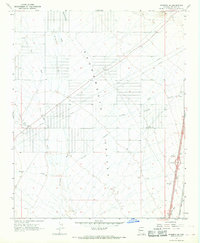
1967 Map of Kingman SW
USGS Topo · Published 1968About this map
The Sacramento Valley dominates this landscape, defined in the late 1960s by its drainage network and transportation corridors. The wide desert floor is etched with ephemeral waterways such as Thirteenmile Wash, Sacramento Wash, and Secret Pass Wash, which gather at the base of the mountains to the east. Modern infrastructure cuts a straight line across the arid terrain, including several segments of Pipeline and the prominent Atchison Topeka and Santa Fe railroad line. The map illustrates a period of mid-century highway development in Mohave County, evidenced by the Griffith Interchange along the primary route to Kingman. While most of the land remains open, localized activity is marked by small-scale features like Fig Spring, several Water Tanks, and a Borrow Pit, reflecting the area's utility for transit and basic water management in a desert environment.
Find a feature on this map
15 named features on this map. Tap any name to fly to it.
Don’t see what you’re looking for? This feature index may not catch every label — zoom into the map to look around manually.
Map Details
Editions of this 1967 Kingman SW Map
3 editions found
Other maps of this area

1886 · Camp Mohave
USGS Topo · 1:250,000

1892 · Camp Mohave
USGS Topo · 1:250,000

1903 · Needles
USGS Topo · 1:125,000

1904 · Needles Special
USGS Topo · 1:125,000

1927 · Yucca
USGS Topo · 1:62,500

1929 · Yucca
USGS Topo · 1:62,500

1942 · Camp Mohave
USGS Topo · 1:250,000

1947 · Kingman
USGS Topo · 1:250,000

1948 · Kingman
USGS Topo · 1:250,000

1954 · Needles
USGS Topo · 1:250,000