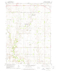
1978 Map of Kingsburg
USGS Topo · Published 1979About this map
Emanuel Creek and its tributary, Little Emanuel Creek, carve a winding path through this agricultural portion of Bon Homme County, defining the drainage patterns south of Avon. The landscape is a transition between organized townships such as Franklin and Albion, showing a rural infrastructure of country schools like Albion Sch and several denominational burial grounds including Evangelical Cem and St Leo Cem. A notable shift in transportation is evident where the Chicago Milwaukee St Paul and Pacific railroad operates in the north, while further south, an Old Railroad Grade near Kingsburg suggests a line no longer in service. The presence of the Drive-in Theater near the Tyndall Corporate Boundary and the Springfield Municipal Airport reflects the mid-to-late 20th-century development of the region's recreational and transit facilities.
Find a feature on this map
23 named features on this map. Tap any name to fly to it.
Don’t see what you’re looking for? This feature index may not catch every label — zoom into the map to look around manually.
Map Details
Editions of this 1978 Kingsburg Map
This is the sole edition of this map. No revisions or reprints were ever made.
Other maps of this area

1898 · Olivet
USGS Topo · 1:125,000

1950 · Niobrara
USGS Topo · 1:24,000

1955 · Sioux City
USGS Topo · 1:250,000

1955 · Sioux Falls
USGS Topo · 1:250,000

1955 · Mitchell
USGS Topo · 1:250,000

1955 · O'Neill
USGS Topo · 1:250,000

1958 · Sioux City
USGS Topo · 1:250,000

1958 · Sioux Falls
USGS Topo · 1:250,000

1959 · O'Neill
USGS Topo · 1:250,000

1959 · Sioux City
USGS Topo · 1:250,000