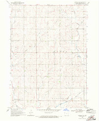
1969 Map of Kingsley NW
USGS Topo · Published 1971About this map
Pleasant Hill Cem sits on the eastern edge of this late-1960s landscape, which is defined by the township boundaries of Marion, Remsen, Union, Henry, Elkhorn, and Garfield. The terrain is deeply incised by a series of south-flowing drainage systems, including Johns Creek, Whisky Creek, and Rathburn Creek, which eventually contribute to the Little Sioux River and its West Fork in the southeastern corner.
Find a feature on this map
17 named features on this map. Tap any name to fly to it.
Don’t see what you’re looking for? This feature index may not catch every label — zoom into the map to look around manually.
Map Details
Editions of this 1969 Kingsley NW Map
This is the sole edition of this map. No revisions or reprints were ever made.
Other maps of this area

1954 · Fort Dodge
USGS Topo · 1:250,000

1955 · Sioux City
USGS Topo · 1:250,000

1957 · Fort Dodge
USGS Topo · 1:250,000

1958 · Sioux City
USGS Topo · 1:250,000

1958 · Fort Dodge
USGS Topo · 1:250,000

1959 · Sioux City
USGS Topo · 1:250,000

1962 · Le Mars
USGS Topo · 1:62,500

1962 · Union Center
USGS Topo · 1:62,500

1969 · Pierson
USGS Topo · 1:24,000

1969 · Fielding
USGS Topo · 1:24,000