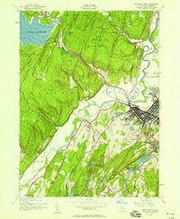
1942 Map of Kingston West
USGS Topo · Published 1950About this map
Ashokan Reservoir dominates the northwestern corner of this landscape, its vast blue waters meeting the rugged slopes of Morgan Hill. In the early 1940s, the region around Kingston shows a complex network of transportation and rural industry, where the New York Central and Western and Ontario railroads serve small communities like West Hurley and Stony Hollow. To the south, the Binnewater Lakes chain—including First Lake, Second Lake, and Third Lake—highlights the watery terrain of Rosendale. This period of wartime development is visible at the Kingston Auxiliary Field and the State Armory, while local infrastructure is anchored by institutions like St Johns Ch and the County Hospital. The map preserves the specific locations of vanishing local landmarks, from the West Hurley RR Station to various district schoolhouses, including Hurley Sch No 4 and the Lower Sawkill School.
Find a feature on this map
54 named features on this map. Tap any name to fly to it.
Don’t see what you’re looking for? This feature index may not catch every label — zoom into the map to look around manually.
Map Details
Editions of this 1942 Kingston West Map
This is the sole edition of this map. No revisions or reprints were ever made.
Other maps of this area

1892 · Kaaterskill
USGS Topo · 1:62,500

1893 · Kaaterskill
USGS Topo · 1:62,500

1894 · Kaaterskill
USGS Topo · 1:62,500

1895 · Catskill
USGS Topo · 1:62,500

1898 · Rhinebeck
USGS Topo · 1:62,500

1899 · Kaaterskill
USGS Topo · 1:62,500

1901 · Rosendale
USGS Topo · 1:62,500

1903 · Rosendale
USGS Topo · 1:62,500

1903 · Kaaterskill
USGS Topo · 1:62,500

1934 · Rhinebeck
USGS Topo · 1:48,000