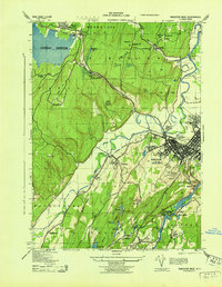
1943 Map of Kingston West
USGS Topo · Published 1943About this map
Ashokan Reservoir dominates the northwestern landscape of this wartime survey, where the New York Central rail line hugs the shoreline near the West Hurley RR Station. The map illustrates a transitional period for Ulster County, capturing the dense urban grid of Kingston alongside agricultural and industrial outposts. Key community landmarks include the Kingston First Reformed Church Spire and the N Y State Armory, while local infrastructure is marked by the Kingston Auxiliary Field and specialized facilities like the Ulster County T B Hospital.
Find a feature on this map
65 named features on this map. Tap any name to fly to it.
Don’t see what you’re looking for? This feature index may not catch every label — zoom into the map to look around manually.
Map Details
Editions of this 1943 Kingston West Map
This is the sole edition of this map. No revisions or reprints were ever made.
Other maps of this area

1892 · Kaaterskill
USGS Topo · 1:62,500

1893 · Kaaterskill
USGS Topo · 1:62,500

1894 · Kaaterskill
USGS Topo · 1:62,500

1895 · Catskill
USGS Topo · 1:62,500

1898 · Rhinebeck
USGS Topo · 1:62,500

1899 · Kaaterskill
USGS Topo · 1:62,500

1901 · Rosendale
USGS Topo · 1:62,500

1903 · Rosendale
USGS Topo · 1:62,500

1903 · Kaaterskill
USGS Topo · 1:62,500

1934 · Rhinebeck
USGS Topo · 1:48,000