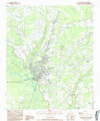
1990 Map of Kingstree
USGS Topo · Published 1990About this map
The Black River defines the western edge of Kingstree in this late twentieth-century topographic study, where the town's urban grid meets the winding waterways and dense wetlands of Williamsburg County. The landscape is characterized by a unique combination of natural and engineered water features, including the Sandy Bay depression and a prominent north-south Canal bordered by Spoil Banks that runs alongside the industrial area of Brockington.
Find a feature on this map
21 named features on this map. Tap any name to fly to it.
Don’t see what you’re looking for? This feature index may not catch every label — zoom into the map to look around manually.
Map Details
Editions of this 1990 Kingstree Map
This is the sole edition of this map. No revisions or reprints were ever made.
Other maps of this area

1946 · Hyman
USGS Topo · 1:62,500

1946 · Kingstree
USGS Topo · 1:62,500
1946 · Lake City
USGS Topo · 1:62,500
1946 · Indiantown
USGS Topo · 1:62,500

1949 · Georgetown
USGS Topo · 1:250,000

1967 · Georgetown
USGS Topo · 1:250,000

1974 · Georgetown
USGS Topo · 1:250,000

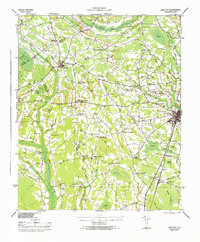
1986 · Kingstree
USGS Topo · 1:100,000
1990 · Hebron Crossroads
USGS Topo · 1:24,000

1990 · Lake City East
USGS Topo · 1:24,000