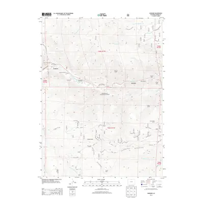
2013 Map of Kinikinik
USGS Topo · Published 2013About this map
The Cache la Poudre River corridor defines the primary axis of human activity on this map, as the Poudre Canyon Hwy winds alongside it, connecting small riverside settlements and recreational sites within the Roosevelt National Forest. The hamlet of Kinikinik and the neighboring community of Idylwilde are central hubs in this mountain landscape, which is marked by historic sites like the Campbell Cem and the Charles E Williams Grave. The river's utility is underscored by the Colorado State Fish Hatchery located near Big Bend Campground. Higher elevations are dominated by the Mummy Range and distinctive landmarks such as Prohibition Mountain and Profile Rock. An extensive network of trails, including the Zimmerman Trail 940 and Roaring Creek Trail 952, suggests a landscape long navigated by foot and pack horse before modern road improvements reached these mountain gulches.
Find a feature on this map
88 named features on this map. Tap any name to fly to it.
Don’t see what you’re looking for? This feature index may not catch every label — zoom into the map to look around manually.
Map Details
Editions of this 2013 Kinikinik Map
This is the sole edition of this map. No revisions or reprints were ever made.
Other maps of this area

1916 · Home
USGS Topo · 1:125,000

1920 · Home
USGS Topo · 1:125,000

1954 · Greeley
USGS Topo · 1:250,000

1957 · Greeley
USGS Topo · 1:250,000

1958 · Greeley
USGS Topo · 1:250,000

1961 · Greeley
USGS Topo · 1:250,000
1962 · Pingree Park
USGS Topo · 1:24,000

1962 · Boston Peak
USGS Topo · 1:24,000
1962 · Comanche Peak
USGS Topo · 1:24,000

1962 · Kinikinik
USGS Topo · 1:24,000