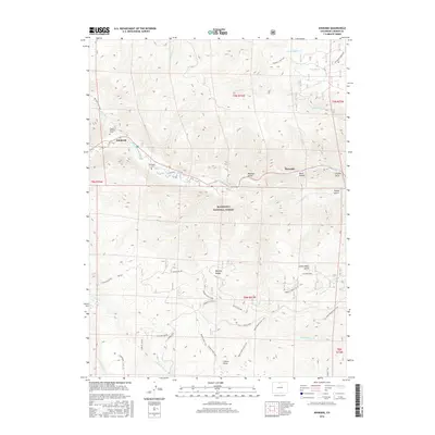
2016 Map of Kinikinik
USGS Topo · Published 2016About this map
Kinikinik and Idylwilde represent the primary points of settlement within this high-elevation corridor of the Roosevelt National Forest. The landscape is defined by the winding course of the Cache la Poudre River, which serves as a central artery for the surrounding mountain terrain. Local history and genealogy are highlighted by the presence of the Campbell Cem and the individual Charles E Williams Grave, providing specific points of interest for researchers tracing early inhabitants of this Larimer County region.
Find a feature on this map
44 named features on this map. Tap any name to fly to it.
Don’t see what you’re looking for? This feature index may not catch every label — zoom into the map to look around manually.
Map Details
Editions of this 2016 Kinikinik Map
This is the sole edition of this map. No revisions or reprints were ever made.
Other maps of this area

1916 · Home
USGS Topo · 1:125,000

1920 · Home
USGS Topo · 1:125,000

1954 · Greeley
USGS Topo · 1:250,000

1957 · Greeley
USGS Topo · 1:250,000

1958 · Greeley
USGS Topo · 1:250,000

1961 · Greeley
USGS Topo · 1:250,000
1962 · Pingree Park
USGS Topo · 1:24,000

1962 · Boston Peak
USGS Topo · 1:24,000
1962 · Comanche Peak
USGS Topo · 1:24,000

1962 · Kinikinik
USGS Topo · 1:24,000