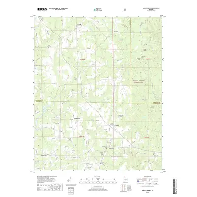
2018 Map of Kinlock Spring
USGS Topo · Published 2018About this map
The Tennessee Valley Divide cuts through this landscape, marking a significant hydrologic boundary where the headwaters of numerous creeks and branches begin their descent. Small communities and rural crossroads such as Carroll Crossroads, Pebble, and Forkville are dispersed across the terrain, connected by a network of county roads. The eastern portion of the survey is dominated by the dense woodlands of the William B. Bankhead National Forest, containing distinctive topographic features like Kinlock Knob and the steep incisions of Buttram Gulf and Hubbard Canyon. This 2018 survey also reveals a high density of rural burial grounds and houses of worship, including the Maxwell Chapel United Methodist Church Cem and the Saint Paul Cem, which serve as vital markers for local genealogical research. In the southwest, the outskirts of Haleyville meet the rolling uplands near the Upper Bear Cr Reservoir.
Find a feature on this map
130 named features on this map. Tap any name to fly to it.
Don’t see what you’re looking for? This feature index may not catch every label — zoom into the map to look around manually.
Map Details
Editions of this 2018 Kinlock Spring Map
This is the sole edition of this map. No revisions or reprints were ever made.
Other maps of this area

1936 · Newburg
USGS Topo · 1:24,000

1936 · Delmar
USGS Topo · 1:24,000

1936 · Kinlock Spring
USGS Topo · 1:24,000

1936 · Phil Campbell
USGS Topo · 1:24,000

1936 · Moulton
USGS Topo · 1:48,000

1936 · Spruce Pine
USGS Topo · 1:24,000

1936 · Goddard
USGS Topo · 1:24,000

1936 · Landersville
USGS Topo · 1:24,000

1940 · Mt Hope
USGS Topo · 1:62,500

1945 · Spruce Pine
USGS Topo · 1:24,000