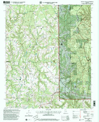
2000 Map of Kinlock Spring
USGS Topo · Published 2003About this map
The Tennessee Valley Divide snakes through this portion of Northwest Alabama, separating the drainage systems of northern and central Alabama. The landscape is dominated by the dense woodlands of the William B. Bankhead National Forest, which includes the protected Sipsey Wilderness and the Black Warrior Wildlife Management Area. These public lands contain quiet landmarks like Kinlock Spring and Cherokee Spring, alongside family-named sites such as Orange Cem and Posey Mill Cem.
Find a feature on this map
39 named features on this map. Tap any name to fly to it.
Don’t see what you’re looking for? This feature index may not catch every label — zoom into the map to look around manually.
Map Details
Editions of this 2000 Kinlock Spring Map
This is the sole edition of this map. No revisions or reprints were ever made.
Other maps of this area

1936 · Newburg
USGS Topo · 1:24,000

1936 · Delmar
USGS Topo · 1:24,000

1936 · Kinlock Spring
USGS Topo · 1:24,000

1936 · Phil Campbell
USGS Topo · 1:24,000

1936 · Moulton
USGS Topo · 1:48,000

1936 · Spruce Pine
USGS Topo · 1:24,000

1936 · Goddard
USGS Topo · 1:24,000

1936 · Landersville
USGS Topo · 1:24,000

1940 · Mt Hope
USGS Topo · 1:62,500

1945 · Spruce Pine
USGS Topo · 1:24,000