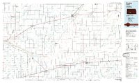
1985 Map of Kinsley
USGS Topo · Published 1985About this map
The Arkansas River meanders across this mid-1980s landscape, serving as a primary corridor through Edwards, Ford, and Kiowa counties. The map captures a vital intersection of transportation and frontier history, notably marked by the Old Indian Treaty Boundary and the Old Military Reservation Boundary near Fort Dodge. These lines speak to the era of western expansion and the strategic importance of the region's early outposts.
Find a feature on this map
51 named features on this map. Tap any name to fly to it.
Don’t see what you’re looking for? This feature index may not catch every label — zoom into the map to look around manually.
Map Details
Editions of this 1985 Kinsley Map
2 editions found
Other maps of this area

1889 · Larned
USGS Topo · 1:125,000

1889 · Kinsley
USGS Topo · 1:125,000

1891 · Great Bend
USGS Topo · 1:125,000

1891 · Medicine Lodge
USGS Topo · 1:125,000

1891 · Larned
USGS Topo · 1:125,000

1892 · Ness
USGS Topo · 1:125,000

1892 · Kinsley
USGS Topo · 1:125,000

1892 · Meade
USGS Topo · 1:125,000

1892 · Dodge
USGS Topo · 1:125,000

1892 · Spearville
USGS Topo · 1:125,000