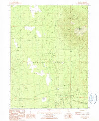
1990 Map of Kinyon
USGS Topo · Published 1990About this map
The Shasta National Forest dominates this section of the southern Cascades, where the McCloud River flows along the southern edge of the survey. The landscape is defined by its transition from high timberlands, such as Black Fox Mountain with its Black Fox Lookout Tower, to broad volcanic basins like Coonrod Flat and Elk Flat. Historical transport and logging infrastructure is evident through the presence of an Old Railroad Grade and the settlement at Kinyon. Further west, Algoma sits near the river, while the oddly named Nitwit Camp and the Ash Creek FS Station indicate a mix of recreational use and forestry management. The hydrology is unique, featuring several disappearing streams including Ash Creek Sink, which drains into the porous volcanic soil common to this region of Siskiyou County.
Find a feature on this map
29 named features on this map. Tap any name to fly to it.
Don’t see what you’re looking for? This feature index may not catch every label — zoom into the map to look around manually.
Map Details
Editions of this 1990 Kinyon Map
This is the sole edition of this map. No revisions or reprints were ever made.
Other maps of this area

1886 · Modoc Lava Bed
USGS Topo · 1:250,000

1886 · Shasta
USGS Topo · 1:250,000

1892 · Modoc Lava-Bed
USGS Topo · 1:250,000

1894 · Shasta
USGS Topo · 1:250,000

1932 · Bartle
USGS Topo · 1:96,000

1935 · Dunsmuir
USGS Topo · 1:125,000

1939 · Bartle
USGS Topo · 1:125,000

1948 · Weed
USGS Topo · 1:250,000

1950 · Weed
USGS Topo · 1:250,000

1954 · Shoeinhorse Mountain
USGS Topo · 1:62,500