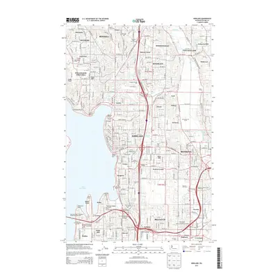
2014 Map of Kirkland
USGS Topo · Published 2014About this map
The eastern shore of Lake Washington and the winding course of the Sammamish River define this highly developed corridor during the early 2010s. Major municipalities like Kirkland, Redmond, and Bothell are shown in their modern urban density, yet the map still preserves the names of smaller, historically distinct neighborhoods and crossroads such as Finn Hill, Juanita, and Oskams Corner. The landscape is a mix of residential growth and recreation, featuring landmarks like the Juanita Golf Course and the Northwest Univ campus.
Find a feature on this map
96 named features on this map. Tap any name to fly to it.
Don’t see what you’re looking for? This feature index may not catch every label — zoom into the map to look around manually.
Map Details
Editions of this 2014 Kirkland Map
This is the sole edition of this map. No revisions or reprints were ever made.
Other maps of this area

1894 · Seattle
USGS Topo · 1:62,500

1895 · Snohomish
USGS Topo · 1:125,000

1897 · Seattle
USGS Topo · 1:125,000

1908 · Seattle
USGS Topo · 1:62,500

1909 · Seattle Special
USGS Topo · 1:62,500

1942 · Edmonds
USGS Topo · 1:62,500

1944 · Everett
USGS Topo · 1:62,500

1949 · Seattle North
USGS Topo · 1:24,000
1949 · Seattle South
USGS Topo · 1:24,000

1950 · Redmond
USGS Topo · 1:24,000