
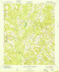
1908 Map of Kirksey
USGS Topo · Published 1942About this map
Sumter National Forest defines much of this South Carolina landscape, where small rural settlements and an extensive network of country schools shaped local life at mid-century. The Georgia and Florida railroad cuts through the northern section, connecting the area to regional markets near Phoenix and Dominicks. Further south, the community of Kirksey serves as a local hub, surrounded by family-named landmarks and watercourses like Cuffytown Creek and Horsepen Creek. The map documents a vanishing era of education and social organization, with numerous specialized schoolhouses such as Brick House Sch, Flint Hill Sch, and Damascus Sch dotting the terrain. For those tracing genealogy or local history, these labels pinpoint the exact locations of neighborhood centers, including Kinard Chapel and Mt Carmel Ch, that once anchored these rural Greenwood and Saluda County communities.
Find a feature on this map
45 named features on this map. Tap any name to fly to it.
Don’t see what you’re looking for? This feature index may not catch every label — zoom into the map to look around manually.
Map Details
Editions of this 1908 Kirksey Map
This is the sole edition of this map. No revisions or reprints were ever made.
Other maps of this area

1892 · Mc Cormick
USGS Topo · 1:125,000

1892 · Abbeville
USGS Topo · 1:125,000

1912 · Mc Cormick
USGS Topo · 1:125,000

1941 · Spartanburg
USGS Topo · 1:250,000
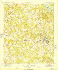
1949 · Ninety-Six
USGS Topo · 1:24,000
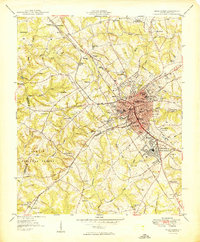
1949 · Greenwood
USGS Topo · 1:24,000
1950 · Bradley
USGS Topo · 1:24,000
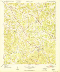
1950 · Kirksey
USGS Topo · 1:24,000

1953 · Athens
USGS Topo · 1:250,000

1953 · Spartanburg
USGS Topo · 1:250,000