
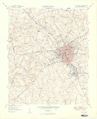
1949 Map of Greenwood
USGS Topo · Published 1949About this map
Greenwood stands as a significant textile and railroad hub at the end of the 1940s, its urban footprint defined by industrial clusters like Greenwood Mill Village, Grendel Mill Village, and Panola Mill Village. The landscape is a complex intersection of five major rail lines, including the Southern Railway and the Seaboard Air Line Railroad, which facilitated the growth of these mill communities and the surrounding commercial district. To the south and west, the terrain shifts into the managed lands of the Sumter National Forest, where smaller settlements like Promised Land and South Greenwood maintain their own networks of community institutions.
Find a feature on this map
90 named features on this map. Tap any name to fly to it.
Don’t see what you’re looking for? This feature index may not catch every label — zoom into the map to look around manually.
Map Details
Editions of this 1949 Greenwood Map
2 editions found
Other maps of this area

1892 · Abbeville
USGS Topo · 1:125,000

1908 · Kirksey
USGS Topo · 1:24,000

1948 · Abbeville East
USGS Topo · 1:24,000

1948 · Verdery
USGS Topo · 1:24,000

1949 · Ninety-Six
USGS Topo · 1:24,000

1950 · Bradley
USGS Topo · 1:24,000

1950 · Kirksey
USGS Topo · 1:24,000

1950 · Verdery
USGS Topo · 1:24,000

1950 · Abbeville East
USGS Topo · 1:24,000

1954 · Greenville
USGS Topo · 1:250,000