
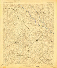
1892 Map of Abbeville
USGS Topo · Published 1892About this map
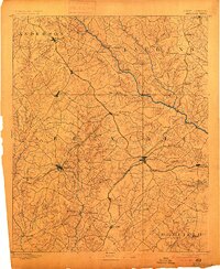
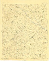
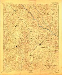
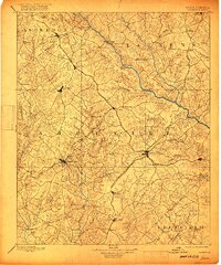
The Abbeville district in the late nineteenth century is characterized by a dense network of early rail lines and river crossings. The Saluda River serves as a primary geographical boundary, spanned by the Free Bridge and Smith Ferry, facilitating movement between the settlements of Ninety-six and Waterloo. This era captures the height of the region's rail expansion, with the Columbia and Greenville Railroad and the Port Royal and Western Carolina Railroad intersecting at Greenwood. The map provides detailed locations of local industry and infrastructure, including Irwin Mill and Maddox Mill along the northern creeks. Topographic landmarks like Parson Mtn. rise above the complex drainage systems of Little River and Cane Creek, while smaller communities such as Due West and Donaldsville anchor the agricultural landscape between the major rail corridors.
Find a feature on this map
86 named features on this map. Tap any name to fly to it.
Don’t see what you’re looking for? This feature index may not catch every label — zoom into the map to look around manually.
Map Details
Editions of this 1892 Abbeville Map
6 editions found
Other maps of this area

1888 · Pickens
USGS Topo · 1:125,000

1892 · Mc Cormick
USGS Topo · 1:125,000

1893 · Elberton
USGS Topo · 1:125,000

1894 · Pickens
USGS Topo · 1:125,000

1906 · Crawfordville
USGS Topo · 1:125,000

1908 · Kirksey
USGS Topo · 1:24,000

1912 · Mc Cormick
USGS Topo · 1:125,000

1941 · Spartanburg
USGS Topo · 1:250,000

1948 · Abbeville East
USGS Topo · 1:24,000
1948 · Verdery
USGS Topo · 1:24,000