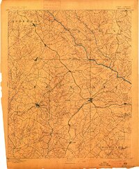
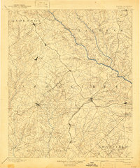
1892 Map of Abbeville
USGS Topo · Published 1900About this map
Abbeville and Greenwood serve as the primary hubs of this Upcountry South Carolina landscape, surveyed in the late nineteenth century just as the rail networks were maturing. The geography is defined by a dense web of watercourses feeding into the Saluda River and Little River, where commerce was facilitated by essential crossings like the Smith Ferry and Free Bridge. The map captures a moment when the Columbia and Greenville Railroad and its Abbeville Branch were central to the region's economy, connecting dozens of small settlements such as Ninety-six, Donaldsville, and Due West.
Find a feature on this map
92 named features on this map. Tap any name to fly to it.
Don’t see what you’re looking for? This feature index may not catch every label — zoom into the map to look around manually.
Map Details
Editions of this 1892 Abbeville Map
6 editions found
Other maps of this area

1888 · Pickens
USGS Topo · 1:125,000

1892 · Mc Cormick
USGS Topo · 1:125,000

1892 · Abbeville
USGS Topo · 1:125,000

1893 · Elberton
USGS Topo · 1:125,000

1894 · Pickens
USGS Topo · 1:125,000

1906 · Crawfordville
USGS Topo · 1:125,000

1908 · Kirksey
USGS Topo · 1:24,000

1912 · Mc Cormick
USGS Topo · 1:125,000

1941 · Spartanburg
USGS Topo · 1:250,000

1948 · Abbeville East
USGS Topo · 1:24,000