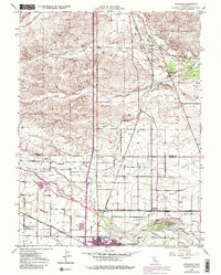
1949 Map of Kirkwood
USGS Topo · Published 1980About this map
Agricultural development and early aviation infrastructure define this Sacramento Valley landscape at the mid-century. The Southern Pacific railroad line anchors the eastern settlements of Kirkwood and Orland, serving as a vital artery for the region's produce and commerce. While the northern terrain is dissected by numerous waterways such as Rice Creek and Sour Grass Creek, the southern half transitions into a structured grid of orchards and farmland, evidenced by naming conventions like Orange Grove Avenue and Olive Avenue.
Find a feature on this map
30 named features on this map. Tap any name to fly to it.
Don’t see what you’re looking for? This feature index may not catch every label — zoom into the map to look around manually.
Map Details
Editions of this 1949 Kirkwood Map
3 editions found
Other maps of this area

1904 · Vina
USGS Topo · 1:62,500

1904 · Walker Creek
USGS Topo · 1:31,680

1906 · Willows
USGS Topo · 1:62,500

1914 · Kirkwood
USGS Topo · 1:31,680

1914 · Orland
USGS Topo · 1:31,680

1914 · Hamilton
USGS Topo · 1:31,680

1914 · McIntosh Landing
USGS Topo · 1:31,680

1919 · Fruto
USGS Topo · 1:62,500

1944 · Fruto
USGS Topo · 1:62,500

1944 · Flournoy
USGS Topo · 1:62,500