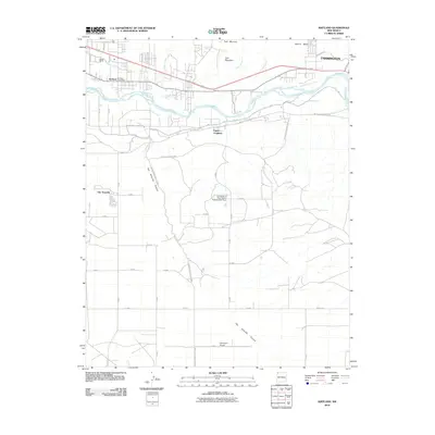
2010 Map of Kirtland
USGS Topo · Published 2010About this map
The San Juan River corridor west of Farmington defines this high-desert landscape in San Juan County. In the early 21st century, the agricultural heritage of the region remains evident through the Farmers Mutual Ditch and the University of New Mexico Experimental Farm. Significant institutional and industrial markers include the Kirtland Post Office and the Harper Hill Pit, while the Davenport Airport serves the higher ground south of the river. The map details several distinct communities, including Kirtland, Upper Fruitland, and Ojo Amarillo, interconnected by a network of local roads like Lower Fruitland Hwy and tribal routes such as Indian Service Route 36. Striking natural features like Twin Mountain and Ojo Amarillo Canyon provide sharp topographic contrast to the developed river valley and the residential blocks of western Farmington.
Find a feature on this map
26 named features on this map. Tap any name to fly to it.
Don’t see what you’re looking for? This feature index may not catch every label — zoom into the map to look around manually.
Map Details
Editions of this 2010 Kirtland Map
This is the sole edition of this map. No revisions or reprints were ever made.
Other maps of this area

1889 · Chaco
USGS Topo · 1:250,000

1892 · Chaco
USGS Topo · 1:250,000

1927 · Sulphur Spring
USGS Topo · 1:96,000

1928 · Kirtland
USGS Topo · 1:125,000

1932 · Kirtland
USGS Topo · 1:125,000

1954 · Shiprock
USGS Topo · 1:250,000

1958 · Shiprock
USGS Topo · 1:250,000

1959 · Shiprock
USGS Topo · 1:250,000
1963 · Farmington North
USGS Topo · 1:24,000
1963 · Youngs Lake
USGS Topo · 1:24,000