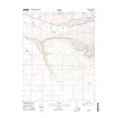
2017 Map of Kirtland
USGS Topo · Published 2017About this map
The San Juan River corridor anchors this northwestern New Mexico landscape, where the agricultural legacy of the valley is clearly delineated by the Fruitland Irrigation Canal tracing the contours of the northern terrace. Settlement patterns are concentrated along the fertile river bottom, with the communities of Kirtland and Upper Fruitland serving as central hubs for the surrounding homesteads and small plots. North of the river, the terrain rises toward prominent landmarks like Twin Mountain and Martin Mesa, while the southern expanse is defined by the significant incision of Ojo Amarillo Canyon. This 2017 data reflects a mix of modern residential growth and long-standing desert infrastructure, showing how drainage features like Coolidge Arroyo and Locke Arroyo dictate the path of local routes including the Old Kirtland Highway.
Find a feature on this map
80 named features on this map. Tap any name to fly to it.
Don’t see what you’re looking for? This feature index may not catch every label — zoom into the map to look around manually.
Map Details
Editions of this 2017 Kirtland Map
This is the sole edition of this map. No revisions or reprints were ever made.
Other maps of this area

1889 · Chaco
USGS Topo · 1:250,000

1892 · Chaco
USGS Topo · 1:250,000

1927 · Sulphur Spring
USGS Topo · 1:96,000

1928 · Kirtland
USGS Topo · 1:125,000

1932 · Kirtland
USGS Topo · 1:125,000

1954 · Shiprock
USGS Topo · 1:250,000

1958 · Shiprock
USGS Topo · 1:250,000

1959 · Shiprock
USGS Topo · 1:250,000
1963 · Farmington North
USGS Topo · 1:24,000
1963 · Youngs Lake
USGS Topo · 1:24,000