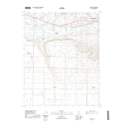
2020 Map of Kirtland
USGS Topo · Published 2020About this map
The San Juan River valley serves as the primary corridor for settlement and agriculture in this High Desert region west of Farmington. The landscape is defined by the vital Fruitland Irrigation Canal, which parallels the river and supports the communities of Kirtland and Upper Fruitland. To the south, the terrain rises sharply from the river bottom into a series of mesas and canyons, including the prominent Ojo Amarillo Canyon and the settlement of Ojo Amarillo. This topographical contrast highlights the reliance on river-fed irrigation systems in an otherwise arid environment characterized by features like Twin Mounds, Twin Mtn, and several drainage channels such as Dain Arroyo and Coolidge Arroyo. The road network, including W Main St and the Old Kirtland Hwy, traces the historical path of development along the northern bank of the river.
Find a feature on this map
77 named features on this map. Tap any name to fly to it.
Don’t see what you’re looking for? This feature index may not catch every label — zoom into the map to look around manually.
Map Details
Editions of this 2020 Kirtland Map
This is the sole edition of this map. No revisions or reprints were ever made.
Other maps of this area

1889 · Chaco
USGS Topo · 1:250,000

1892 · Chaco
USGS Topo · 1:250,000

1927 · Sulphur Spring
USGS Topo · 1:96,000

1928 · Kirtland
USGS Topo · 1:125,000

1932 · Kirtland
USGS Topo · 1:125,000

1954 · Shiprock
USGS Topo · 1:250,000

1958 · Shiprock
USGS Topo · 1:250,000

1959 · Shiprock
USGS Topo · 1:250,000
1963 · Farmington North
USGS Topo · 1:24,000
1963 · Youngs Lake
USGS Topo · 1:24,000