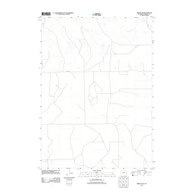
2012 Map of Kirtley SW
USGS Topo · Published 2012About this map
High plains watercourses such as Indian Cr and Middle Cr define this rural landscape in northeastern Wyoming near the turn of the 21st century. The drainage patterns across Niobrara County reveal a network of seasonal and perennial streams including Mill Cr, Fitzsimmons Cr, and Plum Cr, which feed into larger regional basins. Human infrastructure is limited to a sparse grid of section-line roads and local routes, most notably Kirtley Rd and S Bar Rd. This modern survey by the U.S. Geological Survey documents the topographical relief and water resources of a ranching-focused environment, where the proximity of S Bar Cr and Van Tassell Cr suggests a landscape tied to grazing and historical land use patterns common to the High Plains.
Find a feature on this map
9 named features on this map. Tap any name to fly to it.
Don’t see what you’re looking for? This feature index may not catch every label — zoom into the map to look around manually.
Map Details
Editions of this 2012 Kirtley SW Map
This is the sole edition of this map. No revisions or reprints were ever made.
Other maps of this area

1954 · Torrington
USGS Topo · 1:250,000

1958 · Torrington
USGS Topo · 1:250,000

1974 · Mc Master Reservoir
USGS Topo · 1:24,000

1977 · Van Tassell
USGS Topo · 1:24,000
1978 · Node
USGS Topo · 1:24,000

1978 · Shepherds Point
USGS Topo · 1:24,000

1978 · Kirtley SW
USGS Topo · 1:24,000
1978 · Sherrill Hills
USGS Topo · 1:24,000

1978 · Kirtley
USGS Topo · 1:24,000
1981 · Signature Rock
USGS Topo · 1:24,000