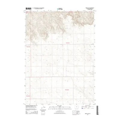
2015 Map of Kirtley SW
USGS Topo · Published 2015About this map
Kirtley Rd serves as the primary east-west artery through this high plains landscape of eastern Niobrara County, reflecting the enduring grid of the Public Land Survey System. The area is defined by a series of north-flowing intermittent drainages, including Fitzsimmons Cr and Middle Cr, which carve subtle topography into the rangeland. These watercourses, alongside others like S Bar Cr and Van Tassell Cr, indicate a drainage pattern toward the Cheyenne River basin to the north. This 2015 update by the U.S. Geological Survey documents the intersection of several townships, such as t33n r61w and t34n r61w, providing a contemporary record of land boundaries and rural infrastructure in a region traditionally dominated by ranching and agriculture.
Find a feature on this map
14 named features on this map. Tap any name to fly to it.
Don’t see what you’re looking for? This feature index may not catch every label — zoom into the map to look around manually.
Map Details
Editions of this 2015 Kirtley SW Map
This is the sole edition of this map. No revisions or reprints were ever made.
Other maps of this area

1954 · Torrington
USGS Topo · 1:250,000

1958 · Torrington
USGS Topo · 1:250,000

1974 · Mc Master Reservoir
USGS Topo · 1:24,000

1977 · Van Tassell
USGS Topo · 1:24,000
1978 · Node
USGS Topo · 1:24,000

1978 · Shepherds Point
USGS Topo · 1:24,000

1978 · Kirtley SW
USGS Topo · 1:24,000
1978 · Sherrill Hills
USGS Topo · 1:24,000

1978 · Kirtley
USGS Topo · 1:24,000
1981 · Signature Rock
USGS Topo · 1:24,000