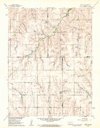
1961 Map of Kirwin SE
USGS Topo · Published 1962About this map
Bohemian Cem and Medicine Creek anchor this agricultural landscape in North Central Kansas, where the borders of four counties—Phillips, Smith, Rooks, and Osborne—converge. Mapped as part of the Department of the Interior program for the development of the Missouri River Basin, the topography is defined by the townships of Valley, Dor, Ash Rock, and Grant. The rural infrastructure is meticulously documented, showing the placement of family and community landmarks like Pleasant Ridge Cem and Spring Branch Cem.
Find a feature on this map
14 named features on this map. Tap any name to fly to it.
Don’t see what you’re looking for? This feature index may not catch every label — zoom into the map to look around manually.
Map Details
Editions of this 1961 Kirwin SE Map
This is the sole edition of this map. No revisions or reprints were ever made.
Other maps of this area
1893 · Smith Center
USGS Topo · 1:125,000
1893 · Phillipsburg
USGS Topo · 1:125,000
1896 · Osborne
USGS Topo · 1:125,000
1896 · Plainville
USGS Topo · 1:125,000
1953 · Woodston NW
USGS Topo · 1:24,000
1953 · Woodston
USGS Topo · 1:24,000
1953 · Alton
USGS Topo · 1:24,000
1955 · Beloit
USGS Topo · 1:250,000
1959 · Beloit
USGS Topo · 1:250,000
1961 · Gaylord SW
USGS Topo · 1:24,000