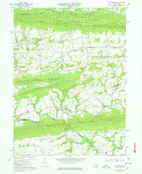
1969 Map of Klingerstown
USGS Topo · Published 1977About this map
The rolling agricultural valleys and forested ridges of central Pennsylvania are defined by the convergence of several townships and counties. Klingerstown sits at a critical junction near the Mahantango Creek, where the borders of Northumberland, Schuylkill, and Dauphin counties meet. The landscape is structured by a series of prominent elevations, including Line Mountain and Fisher Ridge, which isolate the narrow valley floors where small hamlets like Hebe, Erdman, and Rough and Ready developed.
Find a feature on this map
45 named features on this map. Tap any name to fly to it.
Don’t see what you’re looking for? This feature index may not catch every label — zoom into the map to look around manually.
Map Details
Editions of this 1969 Klingerstown Map
3 editions found
Other maps of this area

1892 · Lykens
USGS Topo · 1:62,500

1892 · Shamokin
USGS Topo · 1:62,500

1893 · Sunbury
USGS Topo · 1:62,500

1893 · Lykens
USGS Topo · 1:62,500

1893 · Shamokin
USGS Topo · 1:62,500

1893 · Millersburg
USGS Topo · 1:62,500

1943 · Millersburg
USGS Topo · 1:62,500

1943 · Lykens
USGS Topo · 1:62,500

1943 · Shamokin
USGS Topo · 1:62,500

1943 · Sunbury
USGS Topo · 1:62,500
Featured Places
- West Cameron Township, PA
- Hubley Township, PA
- Lykens Township, PA
- Little Mahanoy Township, PA
- Hebe, Jordan Township