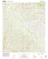
1998 Map of Klondyke
USGS Topo · Published 2002About this map
Klondyke serves as the focal point of this arid canyon landscape, where the Aravaipa Creek valley cuts through the surrounding high desert. The presence of the Klondyke Cem and the nearby Eureka Ranch suggests a community defined by ranching and persistence in a remote environment. High above the valley floor, the Santa Teresa Mountains dominate the northeastern reaches, part of which is protected within the Santa Teresa Wilderness. Small-scale mining history is preserved at the Quinn Mine and Dog Water Mine, while a Landing Strip near the creek indicates the logistical challenges of the terrain. The landscape is also etched with cattle-rearing infrastructure like Salty Tank and the seasonal water sources of Haby Spring, reflecting the essential nature of water management in this part of Arizona.
Find a feature on this map
35 named features on this map. Tap any name to fly to it.
Don’t see what you’re looking for? This feature index may not catch every label — zoom into the map to look around manually.
Map Details
Editions of this 1998 Klondyke Map
This is the sole edition of this map. No revisions or reprints were ever made.
Other maps of this area

1938 · Galiuro Mts
USGS Topo · 1:48,000

1938 · Klondyke
USGS Topo · 1:48,000

1940 · Sierra Bonita Ranch
USGS Topo · 1:62,500

1942 · Sierra Bonita Ranch
USGS Topo · 1:62,500

1943 · Galiuro Mts
USGS Topo · 1:62,500

1943 · Klondyke
USGS Topo · 1:62,500

1943 · Sierra Bonita Ranch
USGS Topo · 1:62,500

1944 · Jackson Mtn.
USGS Topo · 1:62,500

1946 · Jackson Mtn.
USGS Topo · 1:62,500

1956 · Tucson
USGS Topo · 1:250,000