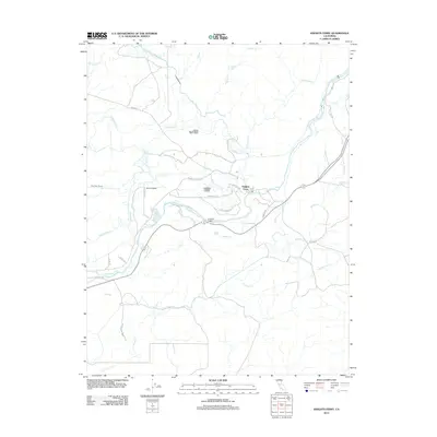
2012 Map of Knights Ferry
USGS Topo · Published 2012About this map
Knights Ferry serves as the central hub of this landscape, situated along the banks of the Stanislaus River. The map details a sophisticated water management network essential to the Central Valley, featuring the North San Joaquin Main Canal, the Hetch Hetchy Aqueduct, and various irrigation structures like the Morrison Siphon Lateral and Cape Horn Lateral. This infrastructure highlights the region's transition from a historic river crossing to a modern agricultural powerhouse. To the west of the settlement, the Cape Horn Tunnel and the distinctive landmark Lovers Leap provide geographic points of interest. The area is further defined by its network of rural roads, such as Sonora Rd and Cemetary Rd, which follow the contours of the drainage basins for Littlejohns Cr and Wildcat Cr.
Find a feature on this map
35 named features on this map. Tap any name to fly to it.
Don’t see what you’re looking for? This feature index may not catch every label — zoom into the map to look around manually.
Map Details
Editions of this 2012 Knights Ferry Map
This is the sole edition of this map. No revisions or reprints were ever made.
Other maps of this area

1915 · Oakdale
USGS Topo · 1:31,680

1915 · Paulsell
USGS Topo · 1:31,680

1916 · Cooperstown
USGS Topo · 1:31,680

1916 · Waterford
USGS Topo · 1:31,680

1916 · Bachelor Valley
USGS Topo · 1:31,680

1916 · Copperopolis
USGS Topo · 1:62,500

1939 · Modesto East
USGS Topo · 1:62,500

1942 · Farmington
USGS Topo · 1:62,500
1942 · Modesto East
USGS Topo · 1:62,500

1942 · Copperopolis
USGS Topo · 1:62,500