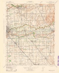
1942 Map of Modesto East
USGS Topo · Published 1942About this map
Agricultural development and water management define the landscape east of Modesto during the early 1940s. The region is heavily bifurcated by the Stanislaus River and Tuolumne River, which support an extensive irrigation network comprising the Modesto Canal, Ceres Canal, and numbered laterals. This complex water system facilitates the dense grid of rural schools serving the valley, including McHenry School, Robinson School, and Mills School.
Find a feature on this map
56 named features on this map. Tap any name to fly to it.
Don’t see what you’re looking for? This feature index may not catch every label — zoom into the map to look around manually.
Map Details
Editions of this 1942 Modesto East Map
This is the sole edition of this map. No revisions or reprints were ever made.
Other maps of this area

1914 · Avena
USGS Topo · 1:31,680

1915 · Oakdale
USGS Topo · 1:31,680

1915 · Paulsell
USGS Topo · 1:31,680

1915 · Westport
USGS Topo · 1:31,680

1915 · Salida
USGS Topo · 1:31,680

1915 · Thalheim
USGS Topo · 1:31,680

1916 · Mitchell School
USGS Topo · 1:31,680

1916 · Crows Landing
USGS Topo · 1:31,680

1916 · Cressey
USGS Topo · 1:31,680

1916 · Montpellier
USGS Topo · 1:31,680