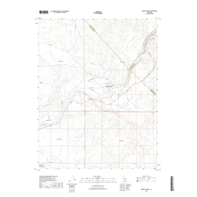
2018 Map of Knights Ferry
USGS Topo · Published 2018About this map
The Stanislaus River carves through the foothills of the Sierra Nevada near the historic community of Knights Ferry, marking the border between Stanislaus, Calaveras, and Tuolumne counties. This modern survey illustrates the complex water management system of the region, featuring the San Joaquin Main Canal and specialized irrigation routes like the Thalheim Lateral, Cape Horn Lateral, and Paulsell Lateral. These features highlight the transition from the rugged upland terrain to the productive agriculture of the San Joaquin Valley. Notable landmarks such as Lovers Leap and Table Mtn provide significant vertical relief, while subterranean engineering is represented by the Cape Horn Tunnel. Local movement is traced through a network of roads including Sonora Rd and Willms Rd, connecting the scattered creeks and canyons that define this landscape at the edge of the Central Valley.
Find a feature on this map
43 named features on this map. Tap any name to fly to it.
Don’t see what you’re looking for? This feature index may not catch every label — zoom into the map to look around manually.
Map Details
Editions of this 2018 Knights Ferry Map
This is the sole edition of this map. No revisions or reprints were ever made.
Other maps of this area

1915 · Oakdale
USGS Topo · 1:31,680

1915 · Paulsell
USGS Topo · 1:31,680

1916 · Cooperstown
USGS Topo · 1:31,680

1916 · Waterford
USGS Topo · 1:31,680

1916 · Bachelor Valley
USGS Topo · 1:31,680

1916 · Copperopolis
USGS Topo · 1:62,500

1939 · Modesto East
USGS Topo · 1:62,500

1942 · Farmington
USGS Topo · 1:62,500
1942 · Modesto East
USGS Topo · 1:62,500

1942 · Copperopolis
USGS Topo · 1:62,500