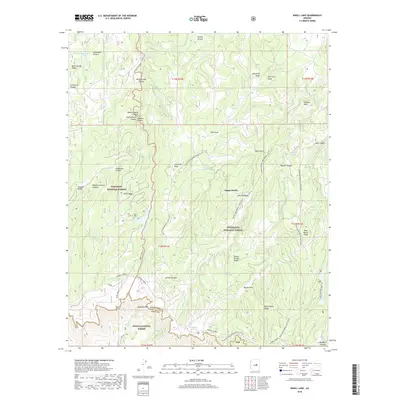
2018 Map of Knoll Lake
USGS Topo · Published 2018About this map
Mogollon Rim dominates the southern landscape of this 2018 survey, where the high plateau of the Coconino National Forest and Sitgreaves National Forest drops sharply into the Tonto National Forest. This abrupt geological transition defines the area's hydrology and transit, with numerous springs like Gentry Spring and Jumping Spring feeding complex canyon systems. The map traces historical and recreational routes, including the prominent General Crook trail and the Babe Haught track, which navigate the rim's edge. Significant water features such as Knoll Lake and Bear Canyon Lake are visible, alongside smaller impoundments like Lake Number Four. This modern topographic study captures the intersection of three major national forests at the boundary of Coconino and Gila counties, providing a detailed view of the rugged corridor between Campo Bonito and Rattlesnake Ridge.
Find a feature on this map
63 named features on this map. Tap any name to fly to it.
Don’t see what you’re looking for? This feature index may not catch every label — zoom into the map to look around manually.
Map Details
Editions of this 2018 Knoll Lake Map
This is the sole edition of this map. No revisions or reprints were ever made.
Other maps of this area

1886 · Holbrook
USGS Topo · 1:250,000

1887 · Verde
USGS Topo · 1:250,000

1892 · Verde
USGS Topo · 1:250,000

1893 · Holbrook
USGS Topo · 1:250,000

1934 · Promontory Butte
USGS Topo · 1:62,500

1939 · Promontory Butte
USGS Topo · 1:62,500

1952 · Promontory Butte
USGS Topo · 1:62,500

1954 · Holbrook
USGS Topo · 1:250,000

1957 · Holbrook
USGS Topo · 1:250,000

1958 · Holbrook
USGS Topo · 1:250,000