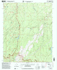
1998 Map of Knoll Lake
USGS Topo · Published 2000About this map
The dramatic Mogollon Rim and Black Mesa Rim define the southern edge of this landscape, where the Colorado Plateau drops away toward the Tonto National Forest. This 1998 revision, based on earlier surveys, details a transition from the high-elevation forests of the Coconino and Sitgreaves National Forests to the rugged canyon country below. Historically significant sites include the Zane Grey Lodge (Site) and the Tonto State Fish Hatchery located near the headwaters of Tonto Spring. The map documents a network of forest roads and pack trails connecting remote outposts like Limestone Ranch and the O'Haco Cabins. Water management is central to this environment, evidenced by numerous tanks and improved springs such as Knoll Lake, Bear Canyon Lake, and Gentry Spring, which support both local wildlife and cattle operations across the ridges and draws.
Find a feature on this map
73 named features on this map. Tap any name to fly to it.
Don’t see what you’re looking for? This feature index may not catch every label — zoom into the map to look around manually.
Map Details
Editions of this 1998 Knoll Lake Map
This is the sole edition of this map. No revisions or reprints were ever made.
Other maps of this area

1886 · Holbrook
USGS Topo · 1:250,000

1887 · Verde
USGS Topo · 1:250,000

1892 · Verde
USGS Topo · 1:250,000

1893 · Holbrook
USGS Topo · 1:250,000

1934 · Promontory Butte
USGS Topo · 1:62,500

1939 · Promontory Butte
USGS Topo · 1:62,500

1952 · Promontory Butte
USGS Topo · 1:62,500

1954 · Holbrook
USGS Topo · 1:250,000

1957 · Holbrook
USGS Topo · 1:250,000

1958 · Holbrook
USGS Topo · 1:250,000