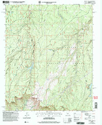
2004 Map of Knoll Lake
USGS Topo · Published 2006About this map
The Mogollon Rim drops away at the southern edge of this landscape, marking the dramatic boundary between three national forests at the turn of the 21st century. The high country is defined by deep drainages like Leonard Canyon and Beaver Creek, where early access points such as Turkey Crossing and Mule Crossing provided vital routes through the dense timber. Water management is central to the area's geography, evidenced by the presence of Knoll Lake, Bear Canyon Lake, and the Tonto State Fish Hatchery. Cultural markers of land use include the O'Haco Lookout and the O'Haco Cabins, reflecting a history of forest service and ranching operations. The network of forest roads, including Forest Road 300, traces the rim's edge, connecting remote locales like Gentry and Campo Bonito within the protected bounds of the Coconino, Sitgreaves, and Tonto national forests.
Find a feature on this map
74 named features on this map. Tap any name to fly to it.
Don’t see what you’re looking for? This feature index may not catch every label — zoom into the map to look around manually.
Map Details
Editions of this 2004 Knoll Lake Map
This is the sole edition of this map. No revisions or reprints were ever made.
Other maps of this area

1886 · Holbrook
USGS Topo · 1:250,000

1887 · Verde
USGS Topo · 1:250,000

1892 · Verde
USGS Topo · 1:250,000

1893 · Holbrook
USGS Topo · 1:250,000

1934 · Promontory Butte
USGS Topo · 1:62,500

1939 · Promontory Butte
USGS Topo · 1:62,500

1952 · Promontory Butte
USGS Topo · 1:62,500

1954 · Holbrook
USGS Topo · 1:250,000

1957 · Holbrook
USGS Topo · 1:250,000

1958 · Holbrook
USGS Topo · 1:250,000