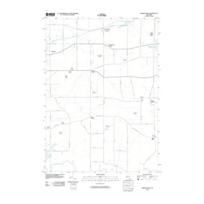
2010 Map of Knowlesville
USGS Topo · Published 2010About this map
Knowlesville and the surrounding farm country of Orleans County are defined by a grid of rural roads and the historic path of the Erie Canal in the northern portion of the quadrangle. Small settlements such as Millville, East Shelby, and West Barre serve as local hubs, while the landscape is dotted with numerous burial grounds of significant genealogical interest, including the Hageman Farm Cemetery and Fletcher Chapel Cemetery. This 2010 survey shows the area's transition into the 21st century, with several private airfields like Maple Ridge Airport and Zelazny Airport established amidst traditional agricultural tracts. The intricate drainage of Fish Creek and Oak Orchard Creek winds through the fields, leading toward Albion Reservoir Number Two. Notable landmarks such as Burma Woods and Pine Hill provide elevation in an otherwise gently undulating terrain managed for utility and transport.
Find a feature on this map
75 named features on this map. Tap any name to fly to it.
Don’t see what you’re looking for? This feature index may not catch every label — zoom into the map to look around manually.
Map Details
Editions of this 2010 Knowlesville Map
This is the sole edition of this map. No revisions or reprints were ever made.
Other maps of this area

1897 · Albion
USGS Topo · 1:62,500

1897 · Medina
USGS Topo · 1:62,500

1897 · Oak Orchard
USGS Topo · 1:62,500

1897 · Ridgeway
USGS Topo · 1:62,500

1944 · Ashwood
USGS Topo · 1:31,680

1944 · Albion
USGS Topo · 1:31,680

1949 · Kendall
USGS Topo · 1:62,500
1949 · Akron
USGS Topo · 1:24,000
1949 · Medina
USGS Topo · 1:24,000
1950 · Knowlesville
USGS Topo · 1:24,000