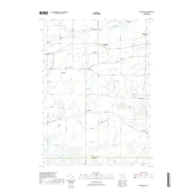
2019 Map of Knowlesville
USGS Topo · Published 2019About this map
The Erie Canal cuts through the northern landscape of Orleans County, defining the early industrial and transit corridor for Knowlesville and Knowlesville Station. This region is characterized by its agricultural heritage and numerous small family and community burial grounds, including the Hageman Farm Cem and Swart Culver Cem. To the south, the terrain shifts into the expansive Oak Orchard Swamp, a significant wetland area where Oak Orchard Creek winds toward the Genesee County line. The map reveals a dense network of country roads connecting small settlements like East Shelby and Millville. Several private airfields, such as Maple Ridge Airport and Zelazny Airport, are scattered across the rural acreage, reflecting the modern utility of these open fields. The presence of Burma Woods and the Albion Reservoir Number Two further highlights the local reliance on both natural timber and managed water resources.
Find a feature on this map
92 named features on this map. Tap any name to fly to it.
Don’t see what you’re looking for? This feature index may not catch every label — zoom into the map to look around manually.
Map Details
Editions of this 2019 Knowlesville Map
This is the sole edition of this map. No revisions or reprints were ever made.
Other maps of this area

1897 · Albion
USGS Topo · 1:62,500

1897 · Medina
USGS Topo · 1:62,500

1897 · Oak Orchard
USGS Topo · 1:62,500

1897 · Ridgeway
USGS Topo · 1:62,500

1944 · Ashwood
USGS Topo · 1:31,680

1944 · Albion
USGS Topo · 1:31,680

1949 · Kendall
USGS Topo · 1:62,500
1949 · Akron
USGS Topo · 1:24,000
1949 · Medina
USGS Topo · 1:24,000
1950 · Knowlesville
USGS Topo · 1:24,000